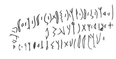
Sigla: C 2276; Dunand 643 a Script: Safaitic
Transliteration
l ʿwḏ bn ġnm bn {l}ḏn bn s²mt bn ġnm bn ʾnʿm bn ʾ{s¹} w rʿy h- mʿzy f h lt s¹lm m- bʾs¹ {w} nqʿṣ l- mn ḏ ḫbl h- s¹fr
Translation
By ʿwḏ son of Ġnm son of {Lḏn} son of S²mt son of Ġnm son of ʾnʿm son of {ʾs¹} and he pastured the goats, so, O Lt, let there be security against misfortune {and} may whosoever would obscure this writing experience a sudden death.
Subjects
Genealogy
Country: Syria
Region: Rif Dimashq
Site: Zalaf (i) "Near the Roman road leading from al-Namārah to the Ruḥbah, on the west side" (C p. 298).
Latitude: 32.9035
Longitude: 37.2962
Present Location: In situ
Find date: 1920s and 1930s
Field collector: Maurice & Mireille Dunand
Notes: Zalaf itself consists of three, or possibly more, wells and some trees, but the Dunands used its name to cover a large area surrounding the place itself. This is subdivided into areas to which we have given the names Zalaf (a) to Zalaf (m). C (p. 199), following the Dunands, says that Zalaf is about 10 km south of Riǧm Qaʿqūl, but in fact it is more like 5.5 km to the south-south-west. Since "Zalaf" is used in C of a wide area, and the descriptions of the sub-areas are often very vague, the co-ordinates given here are necessarily approximate. Approximately, 1.90 km north of the "island" of al-Namārah there is a stone-built barrier, approximately 750 m long from which a wide track cleared of stones runs roughly northwards for approximately 5.6 km to the southern edge of the Ruḥbah. The road was first discovered by C.C. Graham (1858: 239 and map) and was discussed by von Oppenheim (1899–1900, i: 225–226) and Poidebard (1928: 119, fig. 1, pl. XL). There is no firm evidence that it is Roman.
Latitude: southern end of the road approximately 32.9035, northern end approximately 32.9504
Longitude: southern end of the road approximately 37.2962, northern end approximately 37.2951
References:
Graham, C.C. Explorations in the Desert East of the Haurán and in the Ancient Land of Bashan. Journal of the Royal Geographical Society 28, 1858: 226-263, 1 map.
Oppenheim, M. von Vom Mittelmeer zum Persischen Golf durch den Ḥaurān, die syrische Wüste und Mesopotamien. (2 volumes). Berlin: Reimer, 1899-1900.
Poidebard, A. Reconnaissance aérienne au Ledjâ et au Ṣafâ (mai 1927). Syria 9, 1928: 114-123, pls 40-47.
[C] Ryckmans, G. Corpus Inscriptionum Semiticarum: Pars Quinta, Inscriptiones Saracenicae Continens: Tomus I, Fasciculus I, Inscriptiones Safaiticae. Paris: E Reipublicae Typographeo, 1950–1951.
[Dunand] Safaitic inscriptions copied by Maurice and Mireille Dunand in the basalt desert of southern Syria in the 1920s and 1930s and published in G. Ryckmans (ed.), Corpus Inscriptionum Semiticarum. Pars V. Inscriptiones Saracenicas continens, Tomus 1. Inscriptiones Safaiticae. (2 volumes). Paris: Imprimerie nationale, 1950-1951.
URL of this record (for citation): http://krc.orient.ox.ac.uk/ociana/corpus/pages/OCIANA_0005480.html
